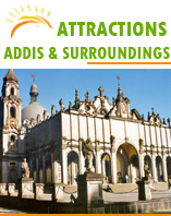
The name of this sprawling capital city means "New Flower." Founded by Emperor Menelik in 1886 and with a population of about 4 million, Addis Ababa is Africa's diplomatic capital with the headquarters for the African Union.
HARARI
The Muslims of Harar wear colorful dress. The men often dress in red, purple or black. The women of Harar part their hair in the middle and make large buns behind their ears. Harari women have been known for their basketwork for centuries and still weave intricate creations from coloured fibers and grasses. Harar is also famous for the work of its silversmiths, who craft beautiful anklets, necklaces, arm bands, silver chains, bangles and earrings out of the precious metal. Although these items can be purchased at the market, some of the best selections can be found in the homes of the craftsmen and women.
DALLOL DEPRESSION
One of the most important features of this region of Africa resulted from faulting and cracking on its eastern side. This has caused the Great Rift Valley, which extends from the Middle East to Mozambique, passing in a north-south direction right through Ethiopia. This shearing of the earth's surface occurred at the same time that the Arabian Peninsula, geologically a part of Africa, was sundered from the rest of the continent. Volcanic activity, which has continued until today, finds expression in volcanoes in Ethiopia's Danakil Depression, as well as in the hot springs in many parts of the country.
Earth tremors are often felt, and exposed cones of old volcanic plugs are seen throughout the plateau. After the Rift opened, much of this area was flooded by the inrushing waters of the red Sea, a flood that was subsequently stemmed by fresh volcanic activity that raised barriers of basaltic lava. Behind these barriers the trapped inland sea that had formed began to evaporate under the fierce heat of the tropical sun - a process that is almost complete today. Only a few scattered, highly saline lakes - Gamarri, Affambo, Bario, and Abbe remain. Elsewhere, there are huge beds of natural salt - which, at points, are calculated to be several thousands of metres thick.
AWASH NATIONAL PARK
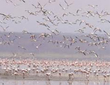
Lying in the lowlands east of Addis Ababa, and striding the Awash River, the Awash National Park is one of the finest reserves in Ethiopia. The Awash River, one of the major rivers of the Horn of Africa, waters important agricultural lands in the north- eastern part of Ethiopia and eventually flows into the wilderness of Danakil Depression. The dramatic Awash Falls as the river tumbles into its gorge is the site not to be missed in the national park. A special attraction is the beautiful clear pools of the hot springs (Filwoha).
Awash National Park, surrounding the dormant volcano of Fantale, is a reserve of arid and semi-arid woodland and Savannah, with reverie forests along the Awash River.
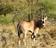
Forty-six species of animals have been identified here, including Beisa Oryx and Swayne's Hartebeest. The bird life is prolific especially along the river and in amongst the 392 species recorded.
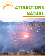
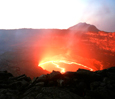
ERTA - ALE
This imperative site is also important as it has an immense ground of salt dipostion which is the source of income of the Afar,since they skillfully mine the saline to supply the country with edible salt. benize this wide carpet of salt is an extensive source of volcanic hit that results babbles of hot water to rise through layers of salt and anhydrite deposit. the never tiring nor non-cooling lava lake at Erta-Ale, one of the stunning place in Afar,boiles it self and at times it spew out small amount of lava to fall shield volcano with an enjoyable colorfull land scapes of reds, browns and yellow, that form captivating fumaroles, amazing rock formations of crystal and mineral deposits across the land. Studies record that the place had experienced large volcanic irruptions until about fourty years ago, yet the continues activate of the lava prevents explosive irruptions.
Situated the North east of Ethiopia in a regoin specially in the Afar region, Denakil Depuration is supposed the most challenging site in Ethiopia.
ABIJATTA - SHALLA LAKE NATIONAL PARK
Using Lake Langano as your base, it is an easy side trip to visit Abijatta-Shalla Lakes National Park, which is 887 square kilometers (550 square miles) in size, 482 (300) of these being water.
The altitude of the park ranges from 1,540 to 2,075 meters (5,051 to 6,806 feet), the highest peak being Mount Fke, situated between the two lakes. The temperature ranges from 45°C (113°F) at maximum and 5°C (41°F) at minimum. Rain falls between March and April and June and September, averaging 500 mm (19.5 inches). The surrounding area is mainly acacia woodland. Abijatta and Shalla are both terminal lakes but very different in nature. Lake Abijatta is 14 meters (46 feet) deep as opposed to Lake Shalla which is 260 meters (853 feet) deep.
MAGO NATIONAL PARK
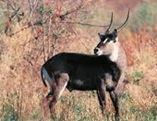
Covering an area of 2,162 square kilometers on the banks of Omo River, the Mago National Park is relatively undeveloped for tourists. The broad grasslands teem with herds of Buffalo, Giraffe, Elephant and Kudu, while sometimes it is possible to find Lion, Leopard and Burchell's Zebra.
The park rises in the north to mount Mago (2,528 meters) and is home to 56 species of mammals. Mago National Park mainly grass savannah, with some forested areas around the rivers. Very dense bush makes for difficult game viewing. The Birds are typical of the dry grassland habitat, featuring bustards, hornbills, weavers, and starlings. Kingfishers and herons can be seen around the Neri River, which provides an alternative habitat.
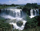
THE SMOKE OF FIRE
Known locally as Tis Isat - 'Smoke of Fire' the Blue Nile Falls is the most dramatic spectacle on either the White or the Blue Nile rivers. Four hundred meters (1,312 feet) wide when in flood, and dropping over a sheer chasm more than forty-five meters (150 Feet) deep the falls throw up a continuous spray of water, which drenches onlookers up to a kilometer away. This misty deluge produces rainbows, shimmering across the gorge, and a small perennial rainforest of lush green vegetation, to the delight of the many monkeys and multicolored birds that inhabit the area. After leaving the village, the footpath Meanders first beside open and fertile fields, then drops into a deep rift that is spanned by an ancient, fortified stone bridge built in the seventeenth century by Portuguese adventurers and still in use. After a thirty-minute walk, a stiff climb up a grassy hillside is rewarded by a magnificent view of the falls, breaking the smooth edge of the rolling river into a thundering cataract of foaming water.
A rewarding but longer trek is to walk along the east bank all the way to the back of the falls; crossing the river by papyrus boat known as 'Tankwa'.
SIMIEN MOUNTAIN NATIONAL PARK
The Simien Mountains massif is a broad plateau, cut off to the north and west by an enormous single crag over 60 kilometers long. To the south, the tableland slopes gently down to 2,200 meters, divided by gorges 1,000 meters deep, which can take more than two days to cross. Insufficient geological time has elapsed to smooth the contours of the crags and buttresses of hardened basalt.
COPY RIGHT - SERENE TOURS ETHIOPIA 2020 Tel: +251 911 239372, +251 930 012709, +251 911 411600E-mail: info@serenetourethiopia.com
DESIGNED BY Mak Link Technology